


The area covered by Natural Resources lies between, 22 degree 46' to 23 degree 38'N latitude and between 86 degree 36' & 87 degree 46'E longitude. It covers an area of 687124 sq. km.
Bankura - the western-most district of West Bengal may be described having the most varied physiographic features. The district can be geologically divided in three categories according to the height of a total land area of 384496 hectors.
-
High hilly region / Hard rock area :- The region consists of the areas like Saltora, Mejia, Khatra, Ranibandh, Gangajalghati etc. covering 176915 Hec. Most of this area does not have irrigation facility.
-
Uneven lands / Hard rock ring area :- This consists of the areas like Bankura, Barjora, Chatna, Onda, Simlapal, Taldangra, Raipur, Sarenga etc. It covers 150611 Hec.
-
Even alluvial lands / alluvial area :- This type of land includes the areas like Bishnupur, Sonamukhi, Patrasayer, Indus, Joypur, Kotulpur etc. covering 56970 hec.
The district of Bankura is included in the Bardhaman division of West Bengal. It is bounded on the north and a part of north-east by the district of Bardhaman from which it is separated by the natural barrier of the Damodar river. The south-east of the district is bounded, over a small distance, by the district of Hooghly, while along the entire southern and western boundaries of Bankura lie respectively the districts of Medinipur and Purulia. High Hilly Region / Hard rock area :- The region consists of the areas like Saltora, Mejia, Khatra, Ranibandh, Gangajalghati etc. covering 176915 hec. Most of these parts don't have the irrigation facility and full of grits. Uneven Lands / Hard rock ring area :- These lands are also grity but irrigated covering 150611 hec..This region consists of the areas like Bankura, Barjora, Chatna, Onda, Simlapal, Taldangra, Raipur, Sarenga etc. Alluvial Lands / Alluvial area :- This type of land includes the areas like Bishnupur, Sonamukhi, Patrasayer, Indus, Joypur, Kotulpur etc. covering 56970 hec. The drought prone area shares the area of 118370 hec., the hilly area stretches over a part of 21432 hec. and 12676 hec. suffers as flood prone. According to soil texture, 60207 hec. is Clay area, 81944 hec. is Loamy-Clay area and the rest part is described as Sandy-Clay area.
MapClick to view Contour Map.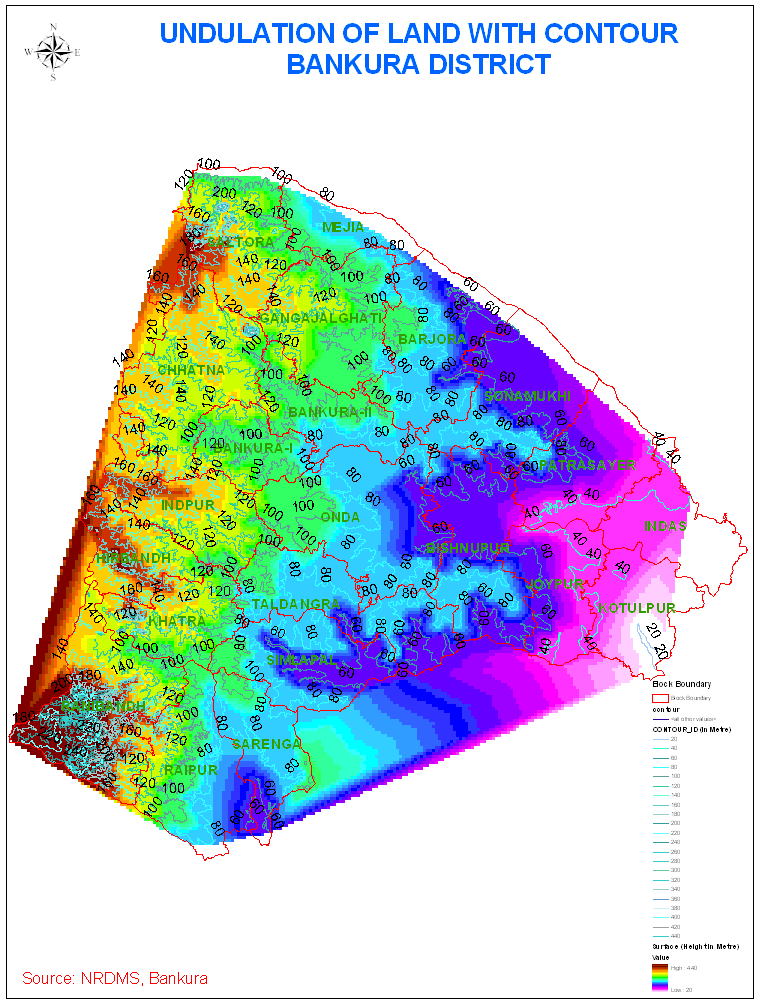
The land-use statistics of Bankura as shown in table 2.6.1 are generated from the INSAT 1C/ 1D satellite image (year 1999). The utilization pattern is not a constant feature. It changes with the lapse of year. Wastelands are reclaimed, more and more areas come under double-cropping and cropped area varies from year to year due to changes natural phenomena, afforertation is done and, at the same time, through cutting and felling, area under open forest also expands
| No. | Description |
Area |
| 1 | Total geographical area |
687387 Hec. |
| 2 | Area under single crop |
241992 Hec. |
| 3 | Area under double crop |
106748 Hec. |
| 4 | Forest area |
119214 Hec. |
| 5 | Open forest |
20712 Hec. |
| 6 | Degraded forest |
57084 Hec. |
| 7 | Eroded land |
33002 Hec. |
Ground-water in the district occurs both under water-table condition and confined condition. Ground-water in the near surface aquifers occur under water-table condition and in deep aquifers, under confined or sub-artesian condition in favorable terrain. The primary source of ground-water is rainfall, a part of which is lost as evaporation and transpiration and another part moves as surface run-off and remaining part percolates into the ground from direct rainfall or by lateral infiltration from surface water-bodies to form saturated ground-water zone.
In the western sector comprising mainly crystalline rock ground-water occurs in the weathered mantle of varying thickness from 6 mts. to 15 mts. under water-table condition. As the water-bearing formations are discontinuous and at places ground-water is held under pressure in the fractured conduits, some water is also retained in the thin cover of soil and alluvium mantling the stream channel. The blocks of Bankura-I, Chhatna, Saltora, Gangajalghati, Ranibandh, Khatra, Hirbandh and Indpur fall under this sector.
In the middle sector covered by laterite and older alluvium, ground-water occurs in the moderately thick to thin acquifer under unconfined to semi-confined condition. In this region, the ground-water is mainly abstracted through open dugwell with limited number of low-duty tubewells. The yield of such low-duty tubewells (75 mts. to 100 mts. depth) varies from 20 to 25 cubic metre / hour. One-cusec medium-duty production tubewells are also feasible in specific location within the depth of 150 mts. BGL. The complete or part of the blocks of Bankura-II, Mejia, Taldangra, Simlapal, Raipur & Sarenga fall under this sector.
In the eastern alluvial area as in Indus, Kotalpur and Joypur Blocks ground-water occurs under confined condition below a blanket of clay whose thickness varies around 10 mts. Medium-duty tubewells are also feasible at Bishnupur, Joypur, Kotalpur, Sonamukhi, Patrasayar, Indus and part of Barjora and Onda blocks where several saturated granular zones are likely to occur in the depth span of 40 mts. to 200 mts. BGL discharging 90 to 180 cubic metre / hour.
![]()
In the year 2001-2002 it has been observed that during the pre-monsoon period there was a great variation in water-level in different part of the district. In a very small part of Patrasayer and Simlapal blocks the water-level was below 3 mts. BGL. In some of the spots auto-flow faintly existed. In a large part of Sonamukhi, Patrasayer, Indus, Barjora, Mejia, Simlapal, Taldangra and a small part of Raipur, water-level was between three to six mts. BGL. The south-western part of Ranibandh and Raipur, western part of Chhatna and Khatra, eastern part of Joypur, Bishnupur and western part of Indus and Kotulpur and in some patches of Taldangra, Onda and Barjora, the water level was above 10 mts. BGL. In rest of the District, water-level was between 6 mts. and 10 mts. BGL.
| Water-level condition from 1998 to 2002 at different hydro-geomorphic zones in Bankura district | |||
Rock type |
Hard rock area in the west |
Hard rock fringe area of the middle |
Alluvial area of the east |
Blocks covered |
Bankura I, Bankura-II, Chhatna, Saltora, Gangajalghati, Indpur, Khatra, Ranibandh, Mejia (part), and Raipur (part) |
Bishnupur, Onda, Barjora, Simlapal, Taldangra, Mejia (part), eastern part of Sarenga |
Bishnupur, Joypur, Kotulpur, Sonamukhi, patrasayer and Indus |
Area in Sq. Km. |
2904 |
2129 |
1848 |
Average depth to water-level condition |
7 mts. to 8 mts. |
7.54 mts. |
6.35 mts. |
Fluctuation (average) |
0.85 mt. |
1.52 mt. |
1.72 mt. |
Annual rate of water-level fluctuation is maximum in Chhatna, Ranibandh, Raipur, Bishnupur, Jaypur, Indus and Kotulpur (4 mts. to 6 mts.). There are some patches in Bankura I, Bankura-II, Barjora, Gangajalghati and Khatra, where the fluctuation is between 4 mts. to 6 mts. In rest of the district the annual water-level fluctuation is 2 mts. to 4 mts. In central Taldangra water-level fluctuation is negligible.
In Bankura-I block, the water-level declines during pre-monsoon from 1 mt. to 2 mts. and, to some extents, maintains the post-monsoon level. The average water-level during pre-monsoon is 6.20 mts. and post-monsoon is 4.50 mts.. In Bankura-II, the water-level also declined during pre-monsoon from 1.5 mts. to 2.5 mts. and rises to some extent during post-monsoon period. The average water-level during pre-monsoon is 6 mts. and post-monsoon 4.65 mts.At Chhatna block, the water-level decreases from 2 mts. to 3 mts. during peak summer and rises to some extent during post-monsoon period from 1 mt. to 1.5 mts. The average water-level is 7.26 mts. during peak summer and 5.15 mts. during post-monsoon. At Saltora block, the condition remains the same as above. Water-level declines upto 2.5 mts. to 3 mts. during peak summer and rises upto 1 mt. during post-monsoon. The average water-level is 6.65 mts. in peak summer and 4.80 mts. during post-monsoon. At Mejia and Gangajalghati, Indpur, Khatra, Ranibandh, it is seen that water level decreases upto 2 mts. in peak summer and rises upto 1 mt. during rainy season. The reason is due to less infiltration by virtue of being hard rock disposition. Average pre-monsoon water level is 8.20 mts., post-monsoon water-level is 5.50 mts. At Barjora block, the water-level condition is somewhat good. The average water level from the last five years is 5.95 mts. during summer and during post-monsoon the water level is 2.15 mts.. The infiltration rate is good nearly from 10 to 15 percent. Pre-monsoon average 7.40 mts., post-monsoon being 4.25 mts. In Sonamukhi block, the water-level during pre-monsoon is 1.82 mts. (average) and 1.48 mts. during post-monsoon period. Water-level condition has not changed much. Similarly the water-level condition of Bishnupur, Onda, Simlapal, Taldangra and a part of Raipur is comparatively good. The water-level decreases only from 0.5 mt. to 1 mt. during peak summer and rises 1 mt. during post-monsoon period. During the peak summer the water-level average of Patrasayer block is 3.99 mts. and during post-monsoon 2.80 mts. The water-level decreased by 1 mt. to 1.5 mts. and rose by 0.50 mt. during rainy season during the last 5 years. Water-level average in pre-monsoon period is 3.10 mts. and in post-monsoon period is 2.45 mts.
MapClick to view Ground Water level.
