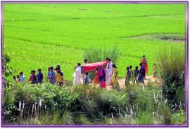
Agriculture accounts for almost 70% of the district's income whereas 80% of the farmers are small & marginal. However due to protective irrigation system, land reforms and use of high fertile & hybrid crops the district is now not so poor as it was. A vast area of bankura is not cultivable due to undulation of land and morum soil. Still the rest of the land (about 60 - 65%) is fertile and due to availability of sufficient water supplied by either by canal or deep tube wells. Several mini artificial water reservoir ("bandh" or barrages) are also available.

Now a days the district cultivate it requires crops. Net cultivable area of the District is 4.30 lakh ha. and nos. of Cultivator is 4.47 lakhs and per cultivator availability of net shown area comes to 1.02 ha. Due to continuous division and fragmentation of cultivated land Agriculture is becoming less remunerative. About 46% of the net cropped area is under Irrigation . The gross cropped area is about 6 lakh ha. and cropping intensity is 147%. Rice, Wheat, Oil seeds and Vegetables are the Principal Crop occupied major of the gross cropped area. Most of the Pre-Kharif and Kharif rice are grown in rainfed condition . H.Y.V. crops occupied about 9% in this district considering 100% in summer rice. Wheat is second most important cereal crop in the district and crop is cultivated in assured / limited irrigated areas. Among different Oil seeds, Rape & Mustared, and Sesamum are two important oil seeds grown in this district Sesamum is cultivated in 3 seasons while Rape & Mustard is cultivated during Rabi season. It is paradoxical that though Bankura lies in sub-humid zone having total Annual Rainfall of 1300 mm to 1400 mm. Agriculture is largely dependent on the vagaries of monsoon. Drought constitutes a major hazard in the district. Intermittent gaps of in precipitation and moisture stress during the monsoon gives rise to serious set back in production during the Kharif, which is the main stay of Agriculture in the district.Farmers are working hard to get more production of crop with their limited area of land. Seed farms are working jointly. Fertilizers are available at every villages.
Agricultural infrastructure :
State Seed Farm |
1 (Bankura |
District Seed Farm |
1 (Susunia) |
Block Seed farm |
5 |
Model Farm |
1 (Joyrambati) |
Agricultural Research Station |
2 (Saltora, Joyrambati) |
Vegetable Seed Farm |
1 (Barjora) |
Other Research Farm |
3 (Rice-Bankura, Dryland-Sushunia, Horticulture-Taldangra) |
No. of Seed Farms |
71 |
No. of Cold Storages |
23 |
Land Utilization Statistics (Area in Hec) :
Geographical Area |
688200 |
Forest |
147293 (21.40%) |
Area under Non Agricultural use |
130473 (18.96%) |
Barren & Uncultivable Land |
3302 (0.48%) |
Permanent Pasture |
501 (0.07%) |
Area under Fruit Crops, Misc Tree Crops and others |
4995 (0.73%) |
Cultivable Waste Land |
2337 (0.34%) |
Fallow other than current fallow |
1386 (0.20%) |
Current Fallow |
13177 (1.92%) |
Net Area sown |
348129 (50.59%) |
Area in which more than once crop is grown |
142318 |
Gross Cropped Area |
490447 |
Cropping Intensity |
141 |
Area under Principal Crops : Consumption of Chemical Fertilizers
Name of the Crop |
Area (in Hec) |
Aus Paddy |
21254 |
Aman Paddy |
311403 |
Boro Paddy |
47625 |
Wheat |
10259 |
Maize |
2702 |
Kalai |
1043 |
Lentil |
1046 |
Musterd |
13314 |
Potato |
42696 |
Summer Vegetables |
8869 |
Winter Vegetables |
13751 |
Kharif Vegetables |
11107 |
Fertilizer used (in M.T.) |
|
Nitrogen (N) |
37947.6 |
Phosphorous (P) |
20463.6 |
Potash (K) |
16088.9 |
Area of fertilizer use (in Hec) |
|
Net sown area |
381402 |
Doubled cropped area |
144355 |
Gross cropped area |
525757 |
Fertilizer used (in Kg/Hec) |
3191 |

Farming system of Bankura district is predominantly rain fed and mono cropped with a crop intensity as low as 147% . Medium and Low Land can maintain growth of Kharif crop but in case of higher land the Kharif crop becomes vulnerable due to moisture deficiency in sub-soil layer and occasional drought occurs, which, if lengthens, crops suffer. Again in the district, scope of harnessing ground water is very limited. 3rd M.I. Census revealed that against 50996 ha. of cultivable command area, actual area irrigated comes to 56494 ha. and its further exploitations will lead only to peril of the people of the district.


